279-acre mixed-use development eyed for Springville
The development, a mix of residential, commercial and education, will coincide with the Iowa DOT's U.S. Highway 151/County Road X-20 interchange construction project.
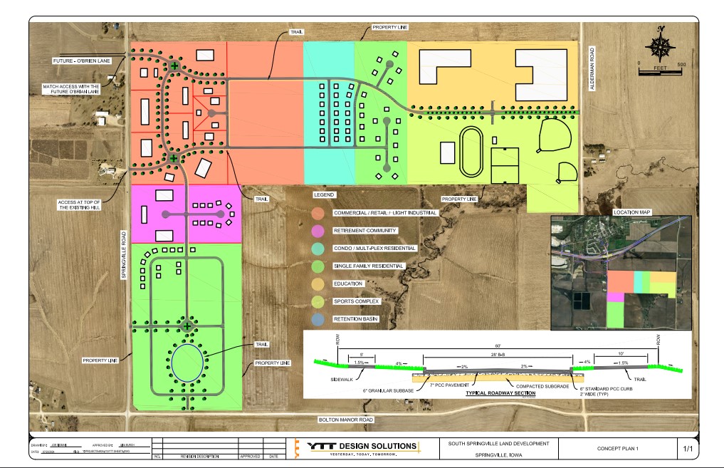
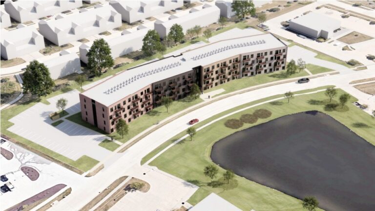
A map of the proposed 279-acre development in Springville, just south of U.S. Highway 151. CREDIT YTT DESIGN SOLUTIONS
A sprawling 279-acre development has been proposed for the town of Springville, located just south of U.S. Highway 151 and adjacent to the U.S. 151/County Road X-20 interchange, which is slated for reconstruction by the Department of Transportation in 2028. The ambitious project envisions a mix of single- and multi-family housing, senior living facilities, commercial […]
Already a subscriber? Log in
Want to Read More?
Get immediate, unlimited access to all subscriber content and much more. Learn more in our subscriber FAQ.
A sprawling 279-acre development has been proposed for the town of Springville, located just south of U.S. Highway 151 and adjacent to the U.S. 151/County Road X-20 interchange, which is slated for reconstruction by the Department of Transportation in 2028.
The ambitious project envisions a mix of single- and multi-family housing, senior living facilities, commercial spaces, space for educational institutions and a sports complex.
Situated on U.S. 151 between Cedar Rapids and Dubuque, Springville is uniquely positioned for exponential growth, said Jim Conlan, the project’s developer and land owner.
He said he passes the town frequently between his headquarters in Dubuque and Iowa City/Cedar Rapids, and its proximity to larger cities and the highway make it an ideal location to accommodate the Corridor’s growth.
A rendering of the finished interchange at U.S. 151 and County Road X-20 (Springville Road) in Springville. CREDIT IOWA DEPARTMENT OF TRANSPORTATION
The proposed interchange construction, aimed at enhancing safety in the area — where the Iowa DOT recorded 61 crashes between 2003 and 2016 — served as a “springboard” for the idea. So, when the land became available, purchasing it seemed like a smart investment.
“I think it will allow the town to do things it hasn’t done before,” said Mr. Conlan, adding that the development should be a “major economic advantage” to the town of 1,154.
In a release, the developer claims the project is expected to bring several benefits to the area, including job creation during construction, expanded housing options, new public spaces, and overall economic growth. Additionally, the project promises to enhance community amenities and boost property values, positioning it as a catalyst for local growth and investment.
Members of the development team include (from left) Jason Rogers, with Q4 Real Estate; Lisa Burch, YTT Design Solutions; and Jim Conlan, developer/land owner. CREDIT ANNIE SMITH BARKALOW
Mr. Conlan and his development team, Lisa Burch with YTT Design Solutions and Jason Rogers with Q4 Real Estate, were on hand to answer residents’ questions at a planning and zoning meeting Oct. 4 at Springville City Hall.
Local residents voiced several concerns during the meeting, some centered around the proposed access points, warning they could lead to increased traffic congestion and safety issues, particularly due to the slow-moving trucks from nearby Wendling Quarries. The possibility of heavy truck traffic has raised apprehension about the impact on road safety and daily commutes.
Infrastructure management was also raised, with unresolved questions about the handling of water and sewer systems. Some homeowners located in the development area also expressed frustration over road alignments, noting that proposed changes could directly impact driveways, potentially complicating traffic flow and safety in the area.
“Seems when you're building a bridge to get rid of the traffic problems, you're creating (something) worse with the traffic trying to get off and on the interstate from the highway, plus all the traffic with its (Wendling Quarries) employees. It's all going to be right in front of our house,” said one resident.
When asked when the project would begin, Mr. Conlan said it would begin as soon as the city approved their request for a temporary access road, and expressed the desire to begin grading this spring.
Currently, the only available farm access is located over half a mile away, and the proposed plan would establish the new farm access at the site of the future O’Brien Lane, which will lead to the quarry.
Planning and Zoning Commission Chair Daryl Pearson, Oct. 8. CREDIT ANNIE SMITH BARAKLOW
“The big picture of this – and I'm not trying to say anything bad to anybody – is, our town needs development,” said Planning and Zoning Commission Chair Daryl Pearson. “Unfortunately, it's going to affect some people more than others. We all pay terrible taxes in a small town because we have no tax base. Our revenue is terrible. And by having these meetings, we're trying to help (residents) that have concerns as much as we can, but still, the development's going to happen.”
Ms. Burch noted that while traffic studies have not yet been conducted to assess the impact on the town, the findings will be shared with the city once they are completed.
Looking ahead, the developer’s next formal steps in the site development process will include submitting a more detailed concept plan, a preliminary plat, and a Planned Development Application for review.